

|
|
|
Fast imaging techniques for time domain data interpretation
Thin sheet approach
The fast imaging technique is very important in geoelectrical exploration. It can be efficiently used in the cases, when the amount of the data is huge, and the real time interpretation result is needed. The typical examples are EM surveys with moving transmitter, in particular, the time domain airborne data.
The family of fast imaging methods based on thin sheet approach has been developed in CEMI recently for the time domain data interpretation. The original method was called S-inversion (Tartaras et al., 2000). Within the framework of this method the electromagnetic response measured at the surface of the earth at every time moment is matched with that of a thin sheet model. The conductivity change with depth is obtained using the conductance, S, and depth, d, of the equivalent thin sheet. By differentiating the conductance, we find the vertical conductivity distribution.
A modification of the S-inversion method was made in 1998-2001 to add possibility to recover the magnetic properties of the rocks (Zhdanov and Pavlov, 1998, 1999, 2001). The new parameter of the thin sheet, the integral magnetic susceptibility, was introduced. New technique is called Sµ-inversion. Now it is possible to recover both conductivity and magnetic permeability from the same time domain magnetic field data.
Figure 1 shows an application of the Sµ-inversion to the synthetic data from the model with both anomalous conductive and magnetic properties. One can see that we could recover anomalous conductivity as well as magnetic permeability.
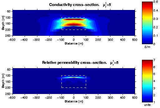
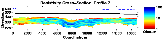
Figure 2 presents conductivity and magnetic permeability cross-sections obtained from the real airborne data provided by ExxonMobil Upstream Research Company. The length of the profile was more than 16 km including 1400 observation points. Sixteen off-time channels were used for inversion.
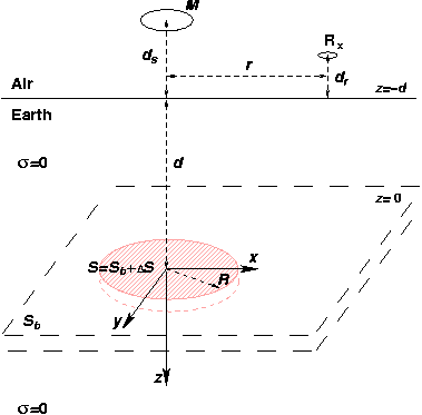
The further development of this technique brought a new method of the localized S-inversion (Zhdanov et al., 2001). The goal was to preserve simplicity and the speed of the original S-inversion, which is 1-D technique, but to add new features to better detect the local objects. The last is very important for mineral exploration. We extended the S-inversion technique, approximating the conductivity cross-section by horizontal conductive thin sheet consisting of a homogeneous background part and a local inhomogeneous part with the anomalous conductance (Figure 3).
Localized S-inversion determines the distribution of this anomalous conductance as a function of a depth and a horizontal coordinate. A new method takes into account a limited horizontal extent of the inhomogeneities, making inversion local. The numerical modeling results demonstrate that the method works reasonably well for typical geoelectrical models. Method can be applied for interpretation of both ground and airborne TDEM data sets.
The picture below (Figure 4) presents a result of the localized S-inversion application to the synthetic airborne data. The actual positions of the targets are delineated by the white squares.
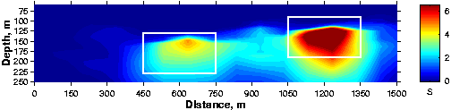
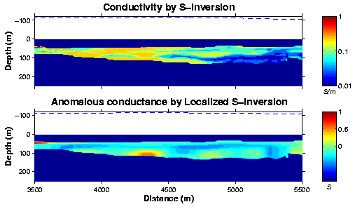
Figure 5 demonstrates an application of the localized S-inversion to the real airborne data set provided by BHP Minerals. Data consists of one profile of airborne dBz/dt component measured in 540 points of observation, 20 time channels, with the interval of approximately 15 m. The length of the profile is more than 8 km. Sixteen off-time channels were used for inversion. The conductive zones at the depth about 100 m are clearly visible in the anomalous conductance image.
Electromagnetic Migration
We developed a fast imaging technique for interpretation of time domain electromagnetic (TDEM) data over inhomogeneous geoelectrical structures. This technique is based on the ideas of electromagnetic migration, which involves the downward continuation of the observed electromagnetic field in reverse time (Zhdanov and Portniaguine, 1997; Zhdanov and Li, 1997). We use the 2.5-D finite difference method for numerical migration of the observed data. We developed the new imaging conditions for transforming the migration field into the conductivity image of underground formations. The methods can be applied for fast imaging of both ground and airborne TDEM data. These problems are very challenging in general, because of multiple source locations. The main advantage of EM migration is its speed. In order to obtain a conductivity image it requires one run of migration routine which is equivalent to the solution of one 2.5-D problem with fixed transmitter position.
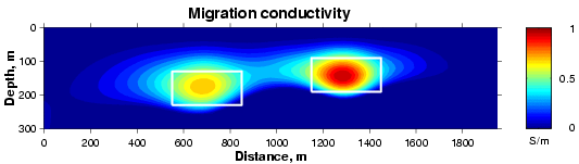
The picture below (Figure 5) presents a result of the EM migration application to the synthetic airborne data. The actual positions of the targets are delineated by the white squares.
References
Pavlov, D. A. and Zhdanov, M. S., 1998, Anomalous Conductivity and Magnetic Permeability Effects in Time Domain Electromagnetic Data: 68th Ann. Internat. Mtg., Soc. Expl. Geophys., Expanded Abstracts, 440-443.
Pavlov, D. A., and Zhdanov M. S. , 1999, Simultaneous inversion of TDEM data for anomalous conductivity and magnetic permeability: 69th Ann. Internat. Mtg., Soc. Expl. Geophys., Expanded Abstracts, 291-294.
Pavlov, D. A. and Zhdanov, M. S., 2001, Analysis and interpretation of anomalous conductivity and magnetic permeability effects in time domain electromagnetic data. Part I: Numerical modeling: Journal of Applied Geophysics, 46, 4, 217-233.
Tartaras, E. and Zhdanov, M. S., 1996, Fast S-inversion in the time domain: method of interpretation using the thin sheet approach: 66th Ann. Internat. Mtg., Soc. Expl. Geophys., Expanded Abstracts, 1306-1309.
Tartaras, E., Pavlov, D. A., and Zhdanov, M. S., 1998, S-inversion of airborne electromagnetic data, 68th Ann. Internat. Mtg., Soc. Expl. Geophys., Expanded Abstracts: 473-476.
Tartaras, E., Zhdanov, M. S., Wada, K., Saito, A., and Hara, T., 2000, Fast imaging of TDEM data based on S-inversion: Journal of Applied Geophysics, 43, No. 1, 15-32.
Zhdanov, M.S. and Li, W., 1997, 2-D finite difference time domain electromagnetic migration: 67th Ann. Internat. Mtg.,Soc. Expl. Geophys., Expanded Abstracts, 370-373.
Zhdanov, M.S, Li, W., and Shiga, N., 1998, Preconditioned time domain electromagnetic migration: 68th Ann. Internat. Mtg., Soc. Expl. Geophys., Expanded Abstracts, 461-464.
Zhdanov, M. S., Traynin, P., and Booker, J., 1996, Underground imaging by frequency domain electromagnetic migration: Geophysics, 61, 666-682.
Zhdanov, M. S., Traynin, P., and Portniaguine, O., 1995, Resistivity imaging by time domain electromagnetic migration: Exploration Geophysics, 26, 186-194.
Zhdanov, M.S., and O. Portniaguine, 1997, Time domain electromagnetic migration in the solution of the inverse problems: Geophysical Journal International, 131, 293-309.
Zhdanov, M. S., and Pavlov, D. A., 2001, Analysis and interpretation of anomalous conductivity and magnetic permeability effects in time domain electromagnetic data. Part II: Sµ-inversion: Journal of Applied Geophysics, 46, 4, 235-248.
Zhdanov, M.S., Pavlov, D. A., and Ellis, R., 2002, Localized S-inversion of time domain electromagnetic data: Geophysics, 67, No. 4, 1115-1125.