

|
|
|
Rapid seabed imaging by frequency domain electromagnetic migration
By Le Wan and Michael S. Zhdanov
The application of EM methods in petroleum exploration requires development of appropriate imaging techniques which provide the means for fast but accurate evaluation of the observed data. In seismic exploration, which is a leading method for oil and gas prospecting, the most widely used imaging technique is seismic migration (Schneider, 1978; Tarantola, 1984; Claerbout, 1985). In a series of publications, Zhdanov and his co-authors have extended the method of seismic migration to the case of a low frequency diffusive EM field (Zhdanov, 1981; Zhdanov and Frenkel, 1983a,b; Zhdanov, 1988; Zhdanov and Keller, 1994; Zhdanov et al., 1996; Zhdanov, 1999; Zhdanov, 2001; and Zhdanov, 2002). Electromagnetic migration has important features in common with seismic migration, but differs in that, for geoelectrical problems, electromagnetic migration is done on the basis of Maxwell's equations, while in the seismic case it is based on the wave equation. Electromagnetic migration, similar to seismic migration, is based on a special form of downward continuation of the observed field or one of its components. This downward continuation is obtained as the solution of the boundary value problem in the lower half-space for the adjoint Maxwell's equations, in which the boundary values of the migration field on the earth's surface are determined by the observed EM data. It was shown in the original paper by Zhdanov and Traynin (1997) that EM migration can be treated as an approximate solution of the corresponding EM inverse problem. It was also demonstrated in subsequent publications (see, for example, Zhdanov, 2002) that EM migration can be applied iteratively, which results in a rigorous inverse EM problem solution.
A method of underground imaging by frequency domain EM migration was developed first for the analysis of land EM data. Tompkins (2004) has reported an application of this migration technique for fast imaging of Sea Bed Logging (SBL) EM data. In CEMI, we have extended the method and numerical algorithm of frequency domain (FD) EM migration developed for processing land EM data, to be effectively used for seabottom imaging of resistive petroleum reservoir structures using marine controlled source electromagnetic (MCSEM) data.
Migration of marine controlled source EM data
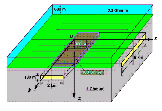
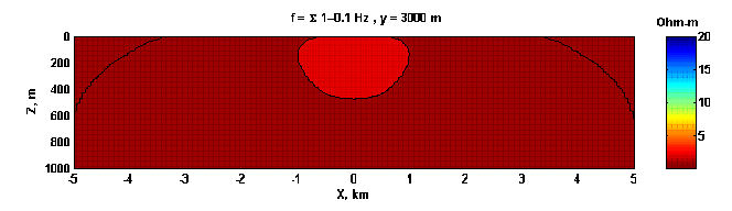
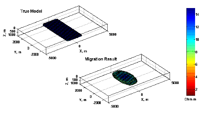
Figure 1 shows a 3-D view of a sea-bottom petroleum reservoir model with the corresponding system of Cartesian coordinates. The depth of the sea bottom is 500 m from the surface, and the sea water resistivity is equal to 0.3 Ohm-m. A petroleum reservoir is modeled by a rectangular resistive body with 2,000 m X 5,000 m sides in the x and y directions, respectively, and with a thickness of 100 m. The top of the reservoir is at 300 m below the sea bottom. The reservoir has 100 Ohm-m resistivity and the surrounding host rock has 1 Ohm-m resistivity. We consider a synthetic marine controlled-source electromagnetic (MCSEM) survey. The electric field is generated by the horizontal (x-oriented) electric dipole (HED) transmitters with a length of 100 m, located at a depth 50 m above the sea bottom along seven lines with the separation between the lines equal to 1 km. The distance between the transmitters along each line is 0.5 km, with 21 transmitter positions along a line. The electric current in the transmitter is 100 A, and the transmitting frequencies are 0.010, 0.0215, 0.0464, 0.10, 0.215, 0.464, 1.0 Hz. This set of transmitters simulates a MCSEM survey with the electric dipole transmitter moving along the observational lines. The electric field generated by the transmitters is recorded by an array of seafloor electric receivers located 5 m above the sea bottom along the same lines with the same separation between the receivers equal to 0.5 km. In total, there are 147 receivers (21 receivers in each of the seven lines) and 147 positions of the transmitters. Using the INTEM3D forward modeling code, we computed the electric data for different frequencies
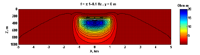
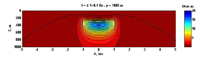
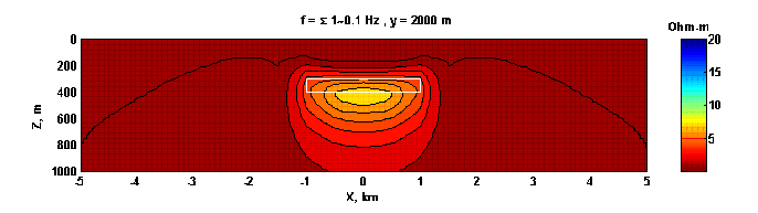
We have migrated the electric fields along all seven profiles and transformed the migration fields in the resistivity cross-sections. The migration results for the MCSEM data are shown in Figures 2- 5. We observe a clear image of the resistive reservoir in these figures. Figure 6 presents a comparison between the true image of the reservoir and a 3-D view of the migration result produced by the interpolation of the migration sections. The reservoir is shown in the right depth, however its thickness is slightly exaggerated.
Conclusion
Marine controlled-source electromagnetics, a new emerging technology of sea-bottom marine EM exploration, is based on collecting an array of electric data at the sea bottom. These data are very well suited for processing and interpreting by the EM migration technique, similar to seismic migration. We have extended to the marine EM case the method of frequency domain EM migration, developed by Zhdanov et al., 1996, for fast analysis of land EM data. We have demonstrated that, the frequency domain EM migration is capable of delivering a fast and stable image of a sea-bottom petroleum reservoir. The migration algorithm is extremely fast. It requires just a few second on a PC, while any standard inversion would take many minutes and even hours of computations. Future research will be focused on more detailed study of the resolution of migration imaging for complex geoelectrical structures and on the application of this technique for fast imaging using different components of controlled source sea-bottom EM field
REFERENCES
Claerbout, J. F, 1985, Imaging the Earth's interior: Blackwell Scientific Publications, Oxford, London, Edinburgh, 399 pp.
Schneider, W. A., 1978, Integral formulation for migration in two and three dimensions: Geophysics, 43, 49-76.
Tarantola, A., 1984, Inversion of seismic reflection data in the acoustic approximation: Geophysics, 49, 1259-1266.
Tompkins, M. J., 2004, Marine controlled-source electromagnetic imaging for hydrocarbon exploration: interpreting subsurface electrical properties: First Break, 22, 27-33.
Zhdanov, M. S., 1981, Continuation of nonstationary electromagnetic fields in geoelectrical problems: Izv. Akad. Nauk SSSR, Fiz. Zemly, 12, 60-69.
Zhdanov, M. S., 1988, Integral transforms in geophysics: Springer-Verlag.
Zhdanov, M. S., and Frenkel, M. A., 1983a, The solution of the inverse problems on the basis of the analytical continuation of the transient electromagnetic field in reverse time: J. Geomag. Geoelectr., 35, 747-765.
Zhdanov, M. S., and Frenkel, M. A., 1983b, Electromagnetic migration: in Hjelt, S. E.., Ed., The development of the Deep Geoelectric model of the Baltic Shield, Part 2, Univ. of Oulu, Oulu, 37-58.
Zhdanov, M. S., and Keller, G., 1994, The geoelectrical methods in geophysical exploration: Elsevier, 873 pp.
Zhdanov, M. S., Traynin, P., and Booker, J., 1996, Underground imaging by frequency domain electromagnetic migration: Geophysics, 61, 666-682.
Zhdanov, M. S., and Traynin, P., 1997, Migration versus inversion in electromagnetic imaging technique: J. Geomag. Geoelec., 49, 1415-1437.
Zhdanov, M. S., 1999, Electromagnetic migration: in Deep Electromagnetic Exploration, Springer-Verlag, Narosa Publishing House, New Delhi, 283-298.
Zhdanov, M. S., 2001, Method of broad band electromagnetic holographic imaging: US Patent #6,253,100 B1.
Zhdanov, M. S., 2002, Geophysical inverse theory and regularization problems: Elsevier, 609 pp.